19/06/2026
Remote Signal Sighting Inspection: Day 5 of Rail Safety Week 2026

Why Signal Sighting is a Safety Challenge
Day 5 of Rail Safety Week and we’re turning our attention to signal sighting.
A signal passed at danger, or SPAD, is a serious incident. Modern safety systems provide important layers of protection to prevent these incidents occurring but they still occur on the railway for a number of reasons.
Currently, across the majority of the UK rail network, the fundamental requirement remains unchanged: drivers must be able to see signals clearly, correctly, and in sufficient time to react – in all conditions, at all times.
Signal sighting is the process that makes this possible. It ensures that every signal on the network is positioned and visible so that drivers can read and respond to it. The process accounts for approach speed, track radius, sighting lines, lighting conditions, seasonal vegetation growth, and the specific characteristics of each train cab.
The scale of the challenge is significant. There are tens of thousands of signals on the UK rail network, each of which needs to be assessed, monitored, and maintained to ensure ongoing compliance with sighting standards. Traditionally, this work has required engineers to be physically present on the track – assessing sight lines in person, often across multiple visits at different seasons or in different conditions. That work is time-consuming, resource-intensive, and exposes signal sighters to the inherent risks of working on or near a live railway.
How Virtual Signal Sighting is Increasing Safety
Forward-facing video captured from in-service trains now makes it possible to carry out signal sighting assessments remotely – reviewing lines of sight, assessing visibility, and identifying issues from a desk, without any trackside exposure.
Signals across the UK have been automatically detected, classified, and mapped across multiple observations. That digital inventory underpins everything from routine sighting reviews to new infrastructure assessments, giving signal sighting teams instant access to the footage and data they need.
Data is captured continuously from in-service and measurement trains, meaning footage is regularly updated and available across seasons and varying conditions — supporting the kind of comprehensive, multi-condition review that would previously have required multiple site visits.
Capabilities Across Signal Sighting
Signal Search and Review
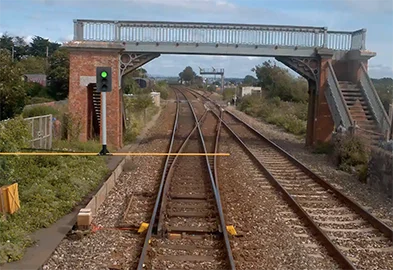
Engineers can search directly for any signal by asset ID, ELR, mileage, or location — navigating instantly to the footage they need. The full session of imagery around each signal is available for review, with the ability to step through approach footage frame by frame to assess visibility at different distances and speeds.
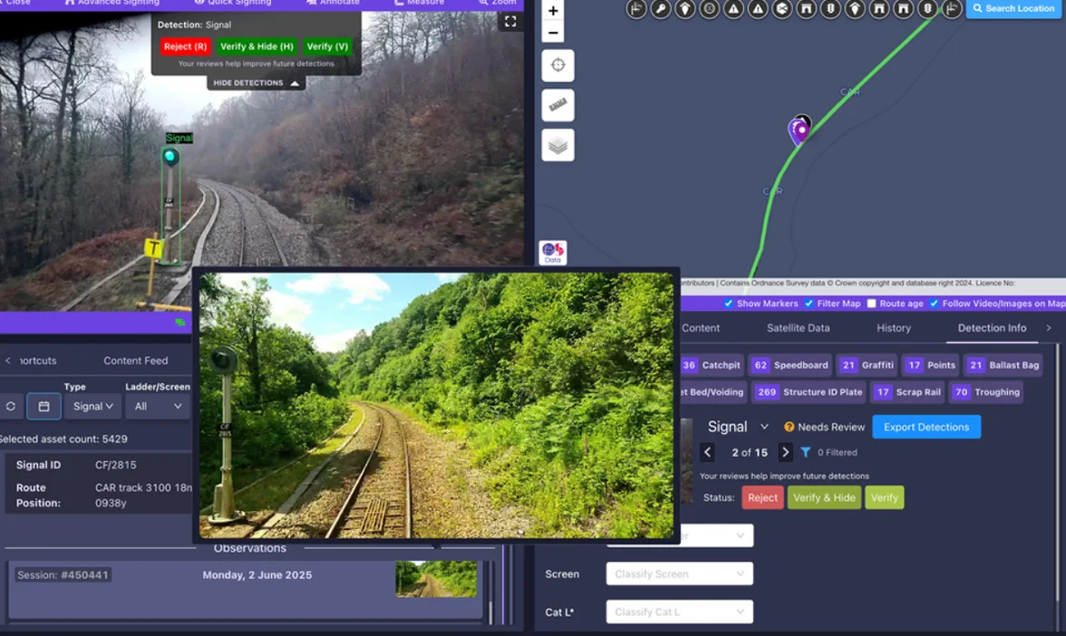
Signal detection and mapping on the AIVR Platform – signals automatically identified, classified, and assigned searchable asset IDs, giving signal sighting teams instant access to the footage they need.
Line of Sight and Distance Measurement
AIVR’s automated sighting tool tracks a signal aspect across multiple frames to calculate the sighting distance and time. It also cross-references with line speed and sighting standards. All this is available to engineers without leaving their desk.
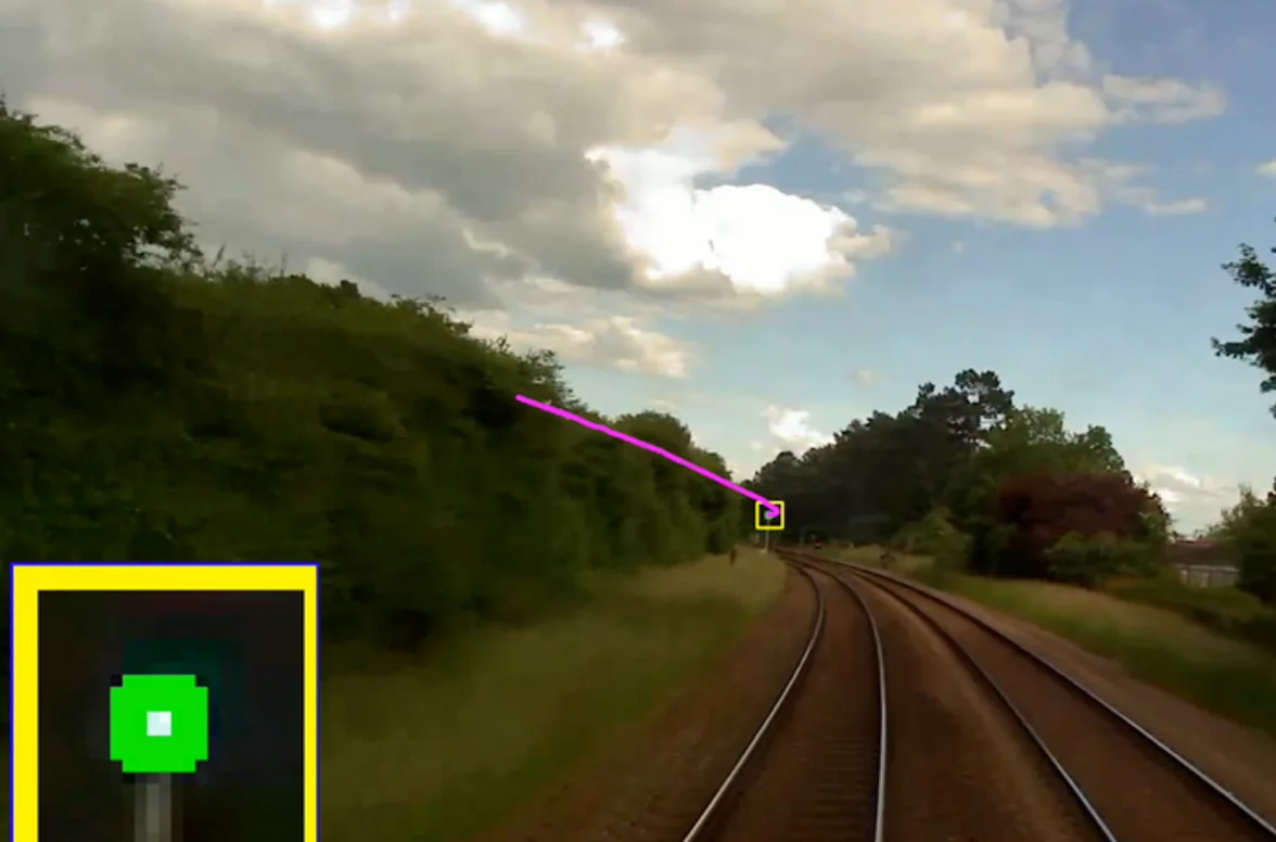
Remote signal sighting on the AIVR Platform –approach visibility assessed from the driver’s perspective, with signal detection overlay and measurement tools available.
Signal Obscuration and Vegetation Detection
Machine learning automatically identifies vegetation encroachment risks affecting signal visibility – detecting obscuration and tracking growth over time. Seasonal comparison allows engineers to review how visibility changes across different times of year, supporting proactive vegetation management before sighting standards are compromised.
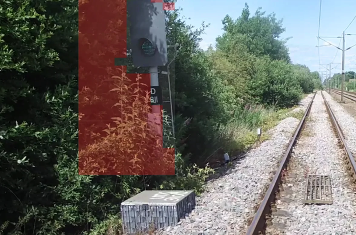
Vegetation obscuration automatically detected on AIVR — AI-powered monitoring identifies growth affecting signal visibility, supporting proactive clearance.
Hazard Identification and Safe Site Access Verification
Before any physical site visit is required, forward-facing footage allows planners to verify safe site access – identifying access points, checking cess boundaries, and annotating potential hazards along the approach. That information can be exported and shared with the team ahead of any trackside attendance.
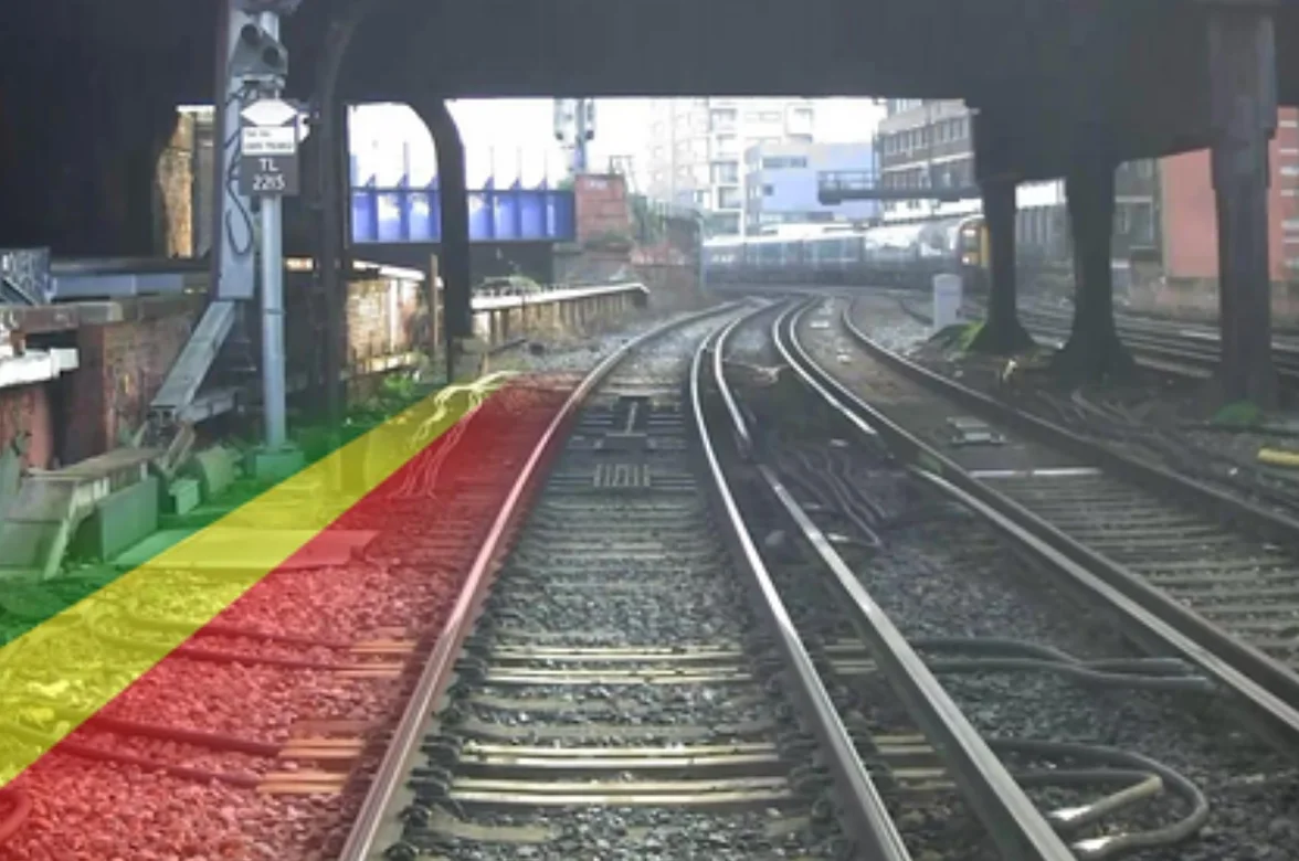
Safe cess monitoring on the AIVR Platform – forward-facing video with cess overlay supporting remote hazard assessment and safe working area verification before teams attend site.
Signal Planning and Design Validation
For new infrastructure schemes, forward-facing footage supports signal planning and design validation – allowing engineers to assess proposed signal locations virtually, validate sighting distances against standards, and identify potential issues before any physical installation takes place. Virtual signal placement within the recorded imagery allows teams to model proposed positions and assess visibility before committing to a design.
Virtual signal placement on the AIVR Platform – a signal model positioned within recorded forward-facing imagery, allowing engineers to assess proposed locations and validate sighting distances before any physical installation takes place.
Collaborative Review and Reporting
Findings can be annotated, exported, and shared across teams — with PDF sighting reports, visual exports, and video clips all available for documentation, stakeholder review, and compliance evidence. Multiple engineers can review the same footage collaboratively, reducing the need for repeat site visits and supporting faster, more consistent decision-making.
Signalling teams across the industry now have the tools to stay ahead of sighting issues rather than discovering them reactively.